Camino de Santiago - French Way - Stage 26, page 1
Molinaseca to Villafranca del Bierzo
Total distance - 30.7 km
Leave Molinaseca by following the main street, Calle Real, until it becomes the main road, taking a right turn after you pass the tennis courts and down a path which runs parallel to the main road. You will meet up again with the main road at the top of a hill where you have a choice of routes.
One route, the right hand one, follows the busy road all the way to Ponferrada and is slightly shorter than the left hand route. The alternative path takes you through the village of Campo and is slightly longer but you are away from the traffic. Directions for both routes are below.
The road route
At the top of the hill keep walking ahead for about 1.5 kilometres where you take a right bend past a furniture warehouse and then cross over the bridge spanning the Rio Boeza. Shortly you will take a slight left bend and walk down a path that leads you to a bridge over the railway line, passing a cemetery before you reach an albergue and the town of Ponferrada.
The off road route via Campo
At the top of the hill take the left hand route following a minor road for approximately 1.5 kilometres until you reach the village of Campo.
The village is now a suburb of Ponferraba and is locally known as Campo de Ponferraba but the village itself has been here for many years, probably dating back to when the Celts lived in the area. It is believed to have originally been called El Castro. The romans settled here as can be seen by the remains of a Roman fountain. During the Middle Ages, before the Spanish inquisition, this area was known as Ponferraba's Jewish quarter. Then as now the Calle Real or main street forms part of the Camino Frances but there are no albergues or places to stay, these disappeared some time in the early 20th century. There is however a café/bar where you can get something to drink.
Continue down Calle Real and take the left hand of 2 roads down a gravelled path. This path will eventually turn into a tarmacked path passing some slightly unsightly buildings including a slaughterhouse and a rather smelly rubbish tip. A little further on you take a left at a sign saying Los Barrios and shortly after cross the medieval Puente Mascarón spanning the Rio Boeza and enter Ponferrada.
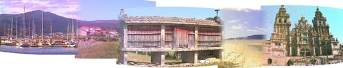
Ponferrada has been around since Celtic times and grew in importance and prosperity during the Roman occupation because of the gold mines in the El Bierzo region, then it was known as Interamnium Flavium. In the Middle Ages it became known as Puebla de San Pedro named after its church and became a major stopping point along the Camino de Santiago. However, getting to the village across the river, which had been set up by Fernando III the king of León, was no mean feat so towards the end of the 11th century Obispo Osmudo, Bishop of Astorga orders a bridge to be built making the Camino easier for the pilgrims. Unlike many bridges of this time which were usually constructed out of stone, this bridge was constructed from iron or ferro as it is called in Spanish. This bridge became known as the Pons-Ferrata (iron bridge) and it was this that eventually gave the city its modern day name of Ponferrada.

The Knights Templar began to settle in the region during the 12th century and the town of Ponferrada was given over to the Knights by King Alfonso IX with the mandate that they protect the pilgrims who were walking the Camino de Santiago through León.
The Knights began to construct el Castillo de los Templarios over the remains of a Roman fortress and completed it in the late 13th century. The current castle was extended during the 15th century and further alterations were done in the 19th and 20th centuries.
Worth visiting whilst you are here is the Basilica de Santa Maria de la Encina. The church was built in the late 16th century and houses the statue of la Virgen de la Encina from whom the church gets its name.

Legend has is that in the middle of the 5th century Santo Toribio de Liébana visited Jerusalem and brought back with him a number of relics, amongst them a statue of the Virgin Mary. This statue stayed for a number of years in Astorga but during the wars with the Moors the relics were hidden in various places to avoid them being plundered by the Saracens. During the Reconquista many of the relics were recovered but the statue of the Virgin disappeared for many centuries.
In 1178 the Knights Templar came to Ponferrada and built their castle. One fine day the man in charge of felling trees in the nearby forest saw a bright light emanating from the forest. He made his way towards the light and as he approached its location he saw that it was coming from the opening in the trunk of a holm oak tree. On closer inspection he found that inside the oak was the statue of the Virgin that had disappeared so many years before. He brought it back to the castle and from then on the Virgin has been known as la Virgen de la Encina or the Virgin of the Holm Oak.

The Royal Prison or Real Cárcel is worth visiting too as it now houses the museum el Museo del Bierzo. The building dates from the late 16th century and has at one time been a judge's house, a prison, hence its name, and the original council offices. The building underwent a total remodel in the late 18th century and following restoration in the mid 1990's it became the town's museum. For anyone who has an interest in weaving and its traditions there is plenty to see here including some old looms.
There is so much beautiful architecture and history to see in Ponferrada that it would be worth spending a whole day here before the arduous trek across the mountains into Galicia.
For accommodation there is the albergue which you passed as you entered Ponferrada but there are also a number of hostals where you can stay. Because of the size of the city there are all the usual amenities such as restaurants, bars and cafés as well as banks if you need to withdraw any money.
Unfortunately the route out of Ponferrada isn't particularly nice, probably the worst on the route but you will soon be walking through the mountains so keep that in mind as you head out.
Walk down the Calle Rañadero and across the bridge over the Rio Sil and turn right down Calle Rio Urdiales, through the big square and towards a junction turning right down the tree lined Avenida del Sacramento. Keep going straight on at the roundabout with the fountain and sculptures on it. At the next junction turn right down Avenida de la Libertad. At the sign for Compostilla turn left, turn right at the end and then take an immediate left underneath an apartment block and into Plaza de Compostilla and walk past the Iglesia Santa Maria de Compostilla.

At the Iglesia Santa Maria de Compostilla cross the road, walk down IV Avenida and then through an unusual residential district. I say unusual because it is very American in style, the sort of town large companies would build to house their workers in the US. Once through the residential district take a left and then a right into 3a Taversia passing the tennis courts and the modern Ermita de Nuestra Señora de Compostilla with its brightly coloured mural on the end wall. From here you will join a footpath which becomes a minor road going underneath the motorway and shortly you will come to the church at the village of Columbrianos.
In Columbrianos you can get something to eat at the café/bar or the shop. The church is a nice spot to rest awhile and look out towards the mountains of Galicia.
Walk through the village and keep on towards the main road. This is very busy so be sensible and use the pedestrian crossing. Be aware Spanish drivers don't really slow down for pedestrians. At the Capilla de San Blas take a left. If you didn't manage to get a drink in Columbrianos there is a small bar just by the small chapel. Walk down the Calle San Blas and cross the railway line and after approximately 2.5 kilometres you come to the small village of Fuentesnuevas where you will find a small café/bar and the Ermita Campo Divino Cristo.
Continued on Stage 26 - page 2.